 Photo Shutterstock
 At the end of 2019, WUR made a map of the Netherlands in 2120. A future scenario of what our country might look like in 2120. A team of Wageningen researchers focused on nature, climate adaptation and the sustainable use of natural resources. Tim van Hattum will present this map and its underlying principles during the Climate Summit in Glasgow at the seminar Bridging science-policy dialogue on climate & food, on Saturday, 6 November.
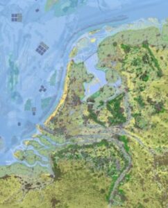
In the future layout of the Netherlands, nature will be given ample room. The amount of forest has doubled, the most fertile lands are used for plant-based food production, and agriculture is almost entirely circular. The coast adapts to the rising sea levels, and rivers have been given much more space. Urban growth is limited to the eastern and southern parts of the country, and cities have more greenery and food forests. The dunes along the coast of the North Sea are doubled in width to protect the Netherlands from the rising sea levels, and large solar and windmill parks are constructed in the North Sea.
The map 2120, ‘A natural future for the Netherlands in 2120’, depicts a possible future scenario in which the Netherlands adapts to climate change, refrains from building in those areas that are below sea level, takes nature and environmental goals into account, and further develops circular agriculture.
Read more about the report.
The presentation can be followed here.