 Photo: Kim Calders
 But that was then. Nowadays, nature conservationists measure the carbon storage of forests with lasers and track poachers with artificial intelligence.
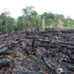
Rainforests are important carbon sinks, but exactly how much carbon does a forest store? Until recently, forest ecologists looked for answers by entering a rainforest in raincoats and clutching machetes, marking a plot the size of two soccer fields and measuring all the trees on that plot –both their height and their diameter. The results were then scaled up to the level of the forest as a whole using modelling.
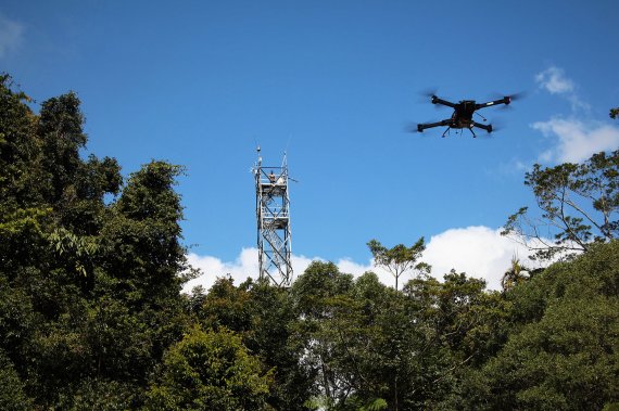
The ecologists of today can do a lot of their work at their computers. British forest ecologist David Coomes, keynote speaker at Wageningen University’s dies natalis on 11 March, uses aeroplanes equipped with laser scanners to scan the forest canopy in an area of 300 square kilometres in Malaysia. These scans provide Coomes with information about the height and growth of the trees and the storage of carbon in the forest. He can repeat these measurement every year, and can thus monitor the fluctuations in CO2 storage over time. This enables him not only to measure the carbon in forests much more precisely, but also to demonstrate whether governments and private sector initiatives are complying with international treaties to stop deforestation and degradation.
Now we can answer questions we hadn’t thought of before
Camera traps
Coomes is a pioneer of the use of new technologies for ecological research. These technologies are developing very fast, as another example makes clear. Ecologists used to arrange expeditions to remote forests to track down rare species. Nowadays they hang up camera traps to record passing wild animals. But Coomes is already testing a new method of recording rare species. One member of his staff collects leeches in the forest. DNA in the blood of this parasite tells the ecologist which mammals it has fed off.
Ecologists from Wageningen University & Research are testing new techniques for their research too, as we learned at the dies natalis. Jasper Eikelboom, a PhD student at the Resource Ecology group, uses GPS devices on animals to detect the presence of poachers in game reserves. The wildlife itself shows him where to look. Eikelboom studies where the deer, wildebeests, lions and other game are in the reserve. From this mass of data, he identifies the spatial-temporal patterns of their usual foraging movements in the reserve. When poachers approach, the animals tend to diverge from those routes, Eikelboom discovered. In a trial with the technique, he was able to predict the presence of poachers in 86 per cent of the cases. The new method, in which Eikelboom uses artificial intelligence, can help game reserve managers to arrest poachers.

Huge datasets
Ecologists were always excellent statisticians, says Coomes, because they had to deal with small datasets and many uncertainties. With these new technologies, they now receive huge datasets. Moreover, they now have access to systems like Google Earth Engine, which speed up the rate at which they can extract useful information from the mass of data.
 en Alvaro Lau (onder)")
Just like Coomes’ group, the Geo-information Science and Remote Sensing group at WUR has embraced new laser technologies. The laser scans this group makes in many tropical forests help the researchers to figure out not only how big the trees are, but also the number and composition of branches and leaves on the trees. ‘We used to have to cut the trees to get this information’, says Professor Martin Herold. Now he gets much more accurate information on hundreds of trees handed to him on a plate.
, Alvaro Lau (mid) en Shutterstock (down)")
Digital twins
‘With this information we can make digital twins of tropical trees’, says Herold. ‘The advantage is that it makes our research more transparent, and other groups can also use three-dimensional tree models for their research.’ As a result, it has become easier to evaluate data on the trees’ internal structure, physiology, resilience to wind, and carbon stocks.
Herold does not know yet what new knowledge will emerge from this. ‘We used to make models from small datasets, so as to scale up the results. We now have loads of measurements and datasets, which we can also combine using powerful software and algorithms. We are entering uncharted territory since we can start to answer questions that we might have not thought about before.’
Illegal logging
Herold also mentions the rapid development of satellite technologies. The world’s forests are being monitored more frequently by more and more satellites. The quality and variety of the images are increasing tremendously. As a result, the satellites can easily spot any changes, including illegal logging in the forests.
Herold’s group is currently engaged in a large-scale research project in Malaysia and Indonesia, where palm oil companies have made an agreement with the Roundtable on Sustainable Palm Oil. The GIS group uses satellite time series to check whether the companies really don’t disturb the natural forest on and near their plantations.
This project also demands new ways of going into action on the basis of the research data, says Herold. ‘If the images raise suspicions that the forest is being disturbed, we are able to send this information quickly and automatically to a local official’s smartphone. For this we need automated, fast detection and machine learning.’
Gold digging
All the new technology enables ecologists to answer fundamental scientific questions more easily, explains Coomes. As an example, his group is studying the question of why some trees in the rainforest grow to heights of up to 100m, towering 20 meters above the canopy. He hopes to find the answer by measuring the height of the trees and assessing a number of variables such as shape, light, soil, water and diseases. But you can also use these techniques for more lucrative activities, says the British scientist, like looking for gold. With the right equipment on board you can find gold in the ground from a plane. Big Brother is watching, even underground.