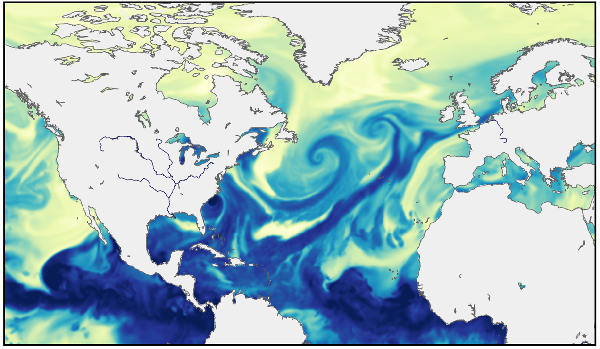
 Figure: Imme Benedict. Atmospheric rivers are clearly visible in satellite images: this figure shows the specific humidity at a height of about 1.5 km, from the ERA5 reanalysis dataset on 14 September 2005 at 07:00. The darker blue the colour, the more moisture (yellow means little moisture).
 Text: Stijn Schreven
In recent years, WUR researchers have seen a clear increase in what are termed ‘atmospheric rivers’, which can cause extreme rainfall in Western Europe. Predicting this interaction between wind and water is a major challenge.
In February, the Rhine’s floodplains were under water. Meltwater and rain in southern Germany and Switzerland led to a high water level of more than 14 metres above sea level at Lobith. But in fact water levels in the Rhine are largely determined by the moisture brought across from the other side of the ocean, says Imme Benedict. She obtained her PhD last year on moisture transport in the atmosphere and the water discharge from rivers. Now she is a lecturer and researcher in the Meteorology and Air Quality group. ‘A lot of evaporation takes place in the Atlantic Ocean, especially close to the tropics, in the Caribbean. Storms start there that travel towards Europe along with the west winds, bringing with them a trail of water vapour.’ That trail can extend more than 2000 kilometres and transport about 15 times as much water as the Rhine; it is then called an atmospheric river. A new one reaches Europe’s Atlantic coast every 10 days. These atmospheric rivers have a big impact on the precipitation in Western Europe, especially in winter when there is little evaporation above land.
An atmospheric river reaches Europe’s Atlantic coast every 10 days
So an atmospheric river is part of one or more storms. Chris Weijenborg, an assistant professor in the same group, studies how such storms originate and how climate change is altering their dynamics. ‘A storm originates as a small change in the air pressure, an anomaly, at the point where warm air from the equator and cold air from the Arctic meet. If the temperature difference between the warm and cold air is big enough, that anomaly automatically grows into a low-pressure area, a storm.’
Storms forecast?
Climate change is making the atmosphere become warmer and making evaporation above the sea increase. Warmer air can hold more moisture: 7 per cent more water for every degree increase in temperature. That is leading to more atmospheric rivers, as Benedict found when working with a Master’s student: ‘We’re already seeing a clear increase in the frequency and intensity of these atmospheric rivers.’
But it’s not clear what will happen with the storms. Weijenborg: ‘Climate change has conflicting effects on storms. On the one hand, the temperature difference between the poles and the equator will become smaller because the poles heat up faster than the equator. That would lead to fewer storms.’ But a storm can also grow due to latent heat, the heat that is released by condensation and rain. More moisture in the atmosphere means more latent heat. ‘The hypothesis is that atmospheric rivers will increase the temperature difference. That would make storms more frequent or more intense.’
Weijenborg suspects the current climate models are not yet able to predict storms very well: ‘They predict that there will be fewer storms and their path will on average shift northwards.’ But it is difficult to say whether that will actually happen because the models are still imperfect. ‘They aren’t accurate when it comes to small storms where latent heat plays a big role. The models’ resolution is not refined enough.’
Jet stream
Whereas atmospheric rivers can lead to extreme rainfall, in recent summers we have suffered extreme drought. The supply of moisture is then blocked for a relatively long period, explains Benedict. This is caused by the jet stream: the strong westerly winds at an altitude of eight to ten kilometres. The temperature gradient between the pole and the equator determines how strong the winds are. Weijenborg: ‘The bigger the temperature difference, the stronger the jet stream.’ But as explained above, that temperature difference will decline with climate change; one theory is that the jet stream will weaken and start meandering more. ‘One such major meander caused a persistent high pressure area above Western Europe in 2018 and blocked the supply of moisture from the sea,’ says Benedict.
Climate change has conflicting effects on storms
If the hypothesis is correct, we can expect such blockages more often in the future. But that is far from certain. Benedict: ‘Not all models predict this trend and there is quite a debate about it at the moment.’ Benedict says the jet stream is the factor driving weather phenomena such as storms and atmospheric rivers but we don’t understand it well enough to make sound predictions. That is cutting-edge research not only in this field but also when extrapolating to predict the impact on land. Benedict: ‘You have to understand the jet stream, but in the end you want to know what effect it will have on us, and then you need to look at atmospheric rivers and droughts.’ So while Weijenborg will be trying to figure out storms over the next few years, Benedict will be focusing on the next time water levels rise.