 Foto: Guy Ackermans
 Soil scientist and legendary fieldwork teacher Gert Peek retired a little over a year ago. Now lecturers Teun Vogel and Jerry Maroulis are working on Peek, an app that makes fieldwork more fun and more enlightening.
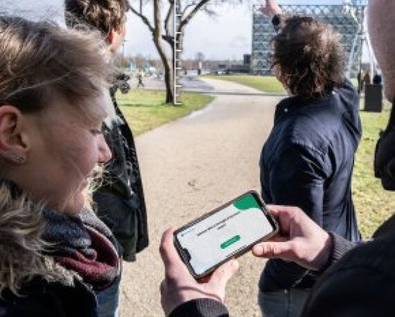
On a grey Monday, four students cross the campus clutching mobile phones. They battle with wind and rain, and get wet feet on a muddy stretch of grass. Their smartphone screens show a map of the area, complete with location markers and question marks. This is Peek, a new educational app developed by lecturers Teun Vogel and Jerry Maroulis of Soil and Landscape Management.
The students stand still in the middle of the field. They have arrived at the first question, which pops up on their screens. ‘How many hectares is the grassy field you are now standing on?’ The students look around them. ‘About one football field? What would that be? One hectare?’ They type that in. ‘Come on!’ appears on the screen: wrong answer. On they go to the next question mark. And so the four progress calmly across the campus, stopping here and there to answer questions. ‘How long is this pond in metres?’ ‘How tall is that tree in metres?’
Estimating is very important in our field
Estimating
These questions test and train the students’ capacity to estimate measurements, explain the app’s creators Vogel and Maroulis. ‘Estimating is very important in our field, but students often find it very hard to do,’ says Vogel. ‘That’s why we made this app.’
It all started last year with an interactive fieldwork experiment in which students went off in small groups into the Belmonte arboretum in Wageningen. As soon as a group of students arrived at a location indicated on the map, they Whatsapped: ‘We are at location 1.’ They got a reply with an estimate question such as: ‘roughly how many bushes are there here?’ They had one minute to answer the question. The answers were put into Excel so that a winner could be announced afterwards, and the answers could be discussed. ‘So students were busy estimating and making decisions together under time pressure. They learned from that and enjoyed it, but it was a lot of work for us,’ says Vogel. ‘A friend of mine was sitting at his laptop all day sending questions and putting the answers into Excel. There was a simpler way to do it.’
 and Teun Vogel")
Many uses
Vogel and Maroulis applied for an education grant and started developing an app. ‘The principle is simple,’ says Maroulis. ‘You use Google Maps and GPS to show exactly where the students must be in order to answer questions. Students go to the locations and fill in their answers. Teachers can download the answers, and then they can easily come back to particular questions and give feedback.’
Maroulis and Vogel soon realised that their app could have more uses than just for learning to estimate. ‘All fieldwork courses can use this app,’ says Maroulis. Vogel adds: ‘You can ask questions like: what do you notice about this landscape? What does the soil look like? What does that mean for land use?’ Maroulis: ‘And the app can be used outside the university too. For anything from school trips to treasure hunts.’
Twenty acres
The developers are certainly enthusiastic, but what about the students? ‘I’m not very good at it yet,’ laughs MSc student of International Land and Water Management Lotte de Jong (26). ‘But the system works well. And estimating will probably get easier once I have more clear reference points, like “The Forum is this high”, or “this field is that long”. Lotte’s coursemate Thijs van der Zaan (24) sees room for improving his estimation skills, too. He thinks the app is useful. ‘A few months ago I was talking to a farmer in Africa. He told me he had 20 acres of land. I thought, well, that is more than the previous farmer had, but I couldn’t estimate how much 20 acres actually is.’
Master’s student of Climate Studies Stefan van Gestel (24) is a bit better at estimating. ‘I have always worked in agriculture, and that helps. But the bigger something is, the harder it is to estimate. The app can help me get better at that.’
Reading landscapes
‘How tall are you? 1 metre 85?’ After a test round, the students go on making estimates. ‘Even when they are not using the app, they are more aware of the world around them,’ says Maroulis. ‘They start reading the landscape, they learn to appreciate it, and they ask themselves why it is being used in a particular way. That kind of awareness is not just useful during a course like this; it is a life skill.’
‘The name is a tribute to Gert Peek’
The new education app for estimating the size of landscape elements is called Peek. For two reasons, explains Soil and Landscape Management lecturer Teun Vogel. ‘In English, to peek is to look, but the name is also a tribute to Gert Peek, one of WUR’s fieldwork heroes. He has retired now, but we thought it would be nice to name the fieldwork app after him. Peek the app as the successor to Peek, the man in the field.’